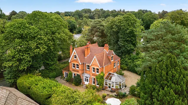
1/20
£1,100,000
Detached · 5 beds · 3 baths · 2,409 sq ft
Sutherland Chase, Ascot, SL5
Freehold
Added on 22/09/2026 
Surrey · 88 sales registered so far in the 12 months to June 2026 · HM Land Registry data
The average (median) house price in Bagshot, Surrey was £427,500 in the 12 months to June 2026, from 88 sales registered so far. That is 2.4% up on the year before and 0.6% up on five years ago. Semi-detached homes were the most common sale at a median £437,500; detached £707,250; terraced £352,500; flats £238,000. Homes with a recorded floor area sold for about £465 per square foot (£5,005/m²), based on 184 of 202 sales over two years.
Sales completed to August 2026, as registered by 4 Oct 2026 · headline figures cover the 12 months to June 2026 (later months are still being registered) Bagshot = the Bagshot post town: GU19 (as recorded in the sales)
| Type | Sales | Median price | £/sq ft | Typical size | Change (1y) |
|---|---|---|---|---|---|
| Detached | 118 | £650,000 | £472 | 1,383 sq ft | n/a |
| Semi-detached | 169 | £435,000 | £482 | 893 sq ft | n/a |
| Terraced | 111 | £355,000 | £493 | 743 sq ft | n/a |
| Flats | 112 | £225,000 | £392 | 587 sq ft | n/a |
| Period | Median sold price | Sales |
|---|---|---|
| 2017 | £365,000 | 81 |
| 2018 | £385,000 | 105 |
| 2019 | £362,500 | 59 |
| 2020 | £398,000 | 91 |
| 2021 | £420,500 | 154 |
| 2022 | £428,650 | 129 |
| 2023 | £425,000 | 92 |
| 2024 | £420,000 | 103 |
| 2025 | £435,000 | 101 |
| 2026 | £420,000 | 47 |
Median of completed sales per period, not seasonally adjusted; the latest months are still being registered.
| Sold | Address | Type | Price | Floor area | £/sq ft | vs last sale |
|---|---|---|---|---|---|---|
| 11 Aug 2026 | 18, Pinewood Gardens GU19 5ES | Terraced | £463,000 | 990 sq ft | £468 | +0% (2022) |
| 7 Aug 2026 | 15, Lory Ridge GU19 5BS | Detached | £540,000 | 1,130 sq ft | £478 | n/a |
| 4 Aug 2026 | 10, Brook Road GU19 5JS | Semi-detached | £480,000 | 1,130 sq ft | £425 | n/a |
| 31 Jul 2026 | 47, Cedar Close GU19 5AB | Semi-detached | £548,000 | 1,098 sq ft | £499 | +0% (2022) |
| 31 Jul 2026 | 34, Waterers Way GU19 5BL | Terraced | £385,000 | 441 sq ft | £872 | +10% (2023) |
| 24 Jul 2026 | Flat 1, 27, Gomer Road GU19 5EA | Flats · Leasehold | £275,000 | 657 sq ft | £419 | n/a |
| 13 Jul 2026 | 29, Drayhorse Drive GU19 5RF | Semi-detached | £275,000 | 463 sq ft | £594 | n/a |
| 10 Jul 2026 | 78, Bagshot Green GU19 5JT | Semi-detached | £410,000 | 980 sq ft | £419 | −1% (2021) |
| 30 Jun 2026 | 16, Heywood Drive GU19 5DL | Detached | £765,000 | 1,507 sq ft | £508 | n/a |
| 29 Jun 2026 | 21, Woodside Close GU19 5FR | Semi-detached | £530,000 | 1,109 sq ft | £478 | +6% (2023) |
| 26 Jun 2026 | Wedgewood, Dukes Covert GU19 5HU | Detached | £1,200,000 | n/a | n/a | n/a |
| 24 Jun 2026 | 2, Chantry Road GU19 5DB | Detached | £800,000 | 1,938 sq ft | £413 | n/a |
| 24 Jun 2026 | 23, Higgs Lane GU19 5DP | Semi-detached | £530,000 | 1,109 sq ft | £478 | n/a |
| 23 Jun 2026 | 2, Higgs Lane GU19 5DP | Semi-detached | £552,500 | 1,690 sq ft | £327 | n/a |
| 19 Jun 2026 | 50, Gloucester Road GU19 5LT | Semi-detached | £420,000 | 797 sq ft | £527 | +8% (2023) |
The most recent registered sales. Full histories, including every sale since 1995, are on the street pages.
Medians over five years for streets with at least five sales; "most active" counts the last 12 months.
| District | Sales (12m) | Median | £/sq ft | Change (1y) |
|---|---|---|---|---|
| GU19 | 88 | £427,500 | £465 | +2.4% |
Homes for sale in Bagshot today ask a median £467,500 (n = 38) vs £427,500 sold, so asking is 9% above recent sold prices; £410 vs £465 per sq ft. 46% of Homello's listings here are under offer. Asking ≠ achieved; sold prices reflect deals agreed 4–6 months ago.






New-build sales register 6–12 months after completion; "resale" means a later sale at an address whose first recorded sale was a new build.
Part of Surrey
A 90 m² (970 sq ft) home in Bagshot is worth roughly £380k–£501k at the area's typical £392–£517 per square foot. That is a range, not a valuation.
Check your addressThe median sold price in Bagshot, Surrey was £427,500 in the 12 months to June 2026 (88 sales registered so far); the mean was £461,601. We quote medians because a few very expensive or very cheap sales pull a mean around. The Surrey median over the same period was £510,000. Portals and the ONS publish different figures because they use different boundaries, windows and adjustments.
Homes sold in Bagshot, Surrey over the two years to June 2026 with a recorded floor area achieved a median £465 per square foot (interquartile range £392–£517), from 184 sales matched to an Energy Performance Certificate floor area.
In the 12 months to June 2026, the median was 2.4% up on the previous 12 months and 0.6% up on five years earlier. These compare completed sales registered so far; the most recent months are still being registered, so the latest figures move as late registrations arrive.
Of streets with at least five sales in the last five years, Dukes Covert (GU19) has the highest median sold price at £1,300,000 across 5 sales.
Every sale is from HM Land Registry's Price Paid Data for England and Wales, which we re-import monthly. Sales completed to August 2026, as registered by 4 Oct 2026 · headline figures cover the 12 months to June 2026 (later months are still being registered). Floor areas come from Energy Performance Certificates matched by address.
One email a month with the sales newly registered here. No account needed, and you can unsubscribe in one click.
Sources and method. Sales completed to August 2026, as registered by 4 Oct 2026 · headline figures cover the 12 months to June 2026 (later months are still being registered).Next HM Land Registry release ~28 Oct 2026. Medians unless stated; averages only where 30 or more sales. Category A sales only (standard price-paid transactions), houses and flats.
Contains HM Land Registry data © Crown copyright and database right 2021. This data is licensed under the Open Government Licence v3.0. Floor areas derived from Energy Performance Certificate data © Crown copyright, licensed under the Open Government Licence v3.0. Contains OS data © Crown copyright and database right 2026. Contains Royal Mail data © Royal Mail copyright and database right 2026. Source: Office for National Statistics licensed under the Open Government Licence v3.0.
How we calculate these figures · Ask us to hide a sale or correct a record