Hornchurch by Hera · North Street, Havering, Greater London RM11 1ST
Hera has 2 developments on Homello. Homes in Hornchurch sold for a median £490,000 over the last year, £494 per sq ft; see house prices in Hornchurch.
About Hornchurch
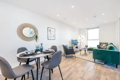
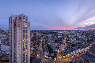
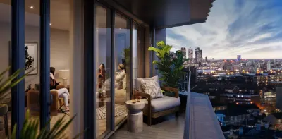
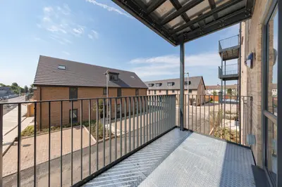
Discover an exceptional standard of modern living at Hornchurch, a premier rental development by Hera, perfectly positioned on North Street in the vibrant heart of Hornchurch town centre. This development offers a sophisticated blend of suburban tranquillity and urban convenience, making it the ideal home for professionals and families seeking a superior lifestyle in Greater London. The building itself has been thoughtfully renovated to provide a collection of contemporary apartments designed for comfort and style.
A diverse range of accommodation is available to suit every need, from stylish studios and one-bedroom apartments to spacious two, three, and even four-bedroom homes. Each apartment is finished to a high standard, featuring modern, all-electric kitchens with integrated appliances, tiled bathrooms, and bright, open-plan living spaces. For ultimate convenience, apartments can be offered unfurnished or furnished to suit your requirements. Residents benefit from an outstanding array of amenities designed for security and ease of living. Secure video entry system and comprehensive CCTV coverage A lift providing access to all floors Complimentary high-speed internet provided by Hyperoptic Secure cycle storage facilities A dedicated property manager and 24/7 out-of-hours support First-come, first-served residents' parking The development’s location is truly second to none. You are just moments away from the bustling Hornchurch High Street, offering a fantastic selection of shops, cafes, and restaurants like Zizzi and Nando's. For leisure, the Queen's Theatre is a short walk away, and numerous parks and gyms are nearby. Excellent transport links provide effortless connectivity across London. Hornchurch station (District Line) and Emerson Park station (Overground) are both within easy walking distance, with journey times to Liverpool Street in under 40 minutes. Multiple bus routes also serve the immediate area, ensuring you are always well-connected. This is a superb opportunity to enjoy a high-quality, secure, and convenient lifestyle in one of Havering's most sought-after locations.
- Developer
- Hera
- City
- Greater London
- Neighbourhood
- Havering
- Postcode
- RM11 1ST
- Address
- North Street
- Tenure
- Build to rent
Facilities
- Free Wi-Fi
- Underground Parking
- Bike Storage
- 24H Maintenance
- Professionally Managed
- CCTV Coverage in All Common Areas
- Keyless Entry
- Lift
- On site Security
Questions about Hornchurch
›Who is the developer of Hornchurch?
Hornchurch is a Hera development in Havering, Greater London. Hera has 2 developments listed on Homello.
›What are house prices like in Hornchurch?
The median sold price in Hornchurch was £490,000 over the last 12 months (807 sales, +4.3% on the year before), or £494 per square foot, from HM Land Registry data. The house prices in Hornchurch page has the trend, prices by property type and every street.
Location
North Street, RM11 1ST
Nearest stations
- Emerson Park Station 0.1 milesLiberty line
- Hornchurch Station 0.9 milesDistrict line
- Upminster Bridge Station 0.9 milesDistrict line
- Gidea Park Station 1.2 milesElizabeth line · Greater Anglia
Nearest schools
- Langtons Junior Academy 0.3 milesPrimary · ages 7–11 Good
- Langtons Infant School & Nursery 0.3 milesPrimary · ages 3–7 Good
- Towers Infant School 0.4 milesPrimary · ages 2–7 Outstanding
- Towers Junior School 0.4 milesPrimary · ages 7–11
Nearest supermarkets
- Asda Express Convenience store 0.1 miles
- Iceland Supermarket 0.3 miles
- Sainsburys Large supermarket 0.3 miles
- Lidl Supermarket 0.3 miles
Eating out nearby
Within half a mile: 55 restaurants and cafes, 7 pubs and bars, 5 takeaways.
- The New Garden Cafe <0.1 milesRestaurant or cafe
- Emerson Dhaba Bar & Grill <0.1 milesRestaurant or cafe
- Mio Yatai <0.1 milesRestaurant or cafe
- Fu Wing <0.1 milesTakeaway
Straight-line distances; actual routes will be longer. Stations from NaPTAN, with their lines powered by TfL Open Data; schools from the Department for Education register, with the latest Ofsted signal; supermarkets from Geolytix Retail Points; places to eat from the Food Standards Agency's register of food businesses.
Area insights
The Havering neighbourhood around this development.
Sources: HM Land Registry price paid data, Police.uk, Historic England, ONS Census 2021, Ofcom Connected Nations, Environment Agency. Planning offices.
Register for launch pricing and availability.