The Keel by Allsop · Kings Parade, Liverpool, Merseyside L3 4GE
Allsop has 5 developments on Homello. Homes in Liverpool sold for a median £210,000 over the last year, £230 per sq ft; see house prices in Liverpool.
About The Keel
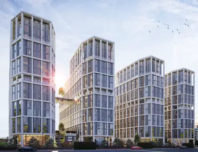
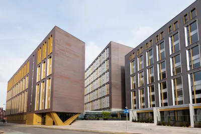
Discover an exceptional rental experience at The Keel, a landmark development managed by Allsop, offering a unique waterside lifestyle on Kings Parade, Liverpool. This award-winning building presents 240 beautifully designed apartments with stunning views over the River Mersey, blending tranquil living with the vibrant energy of the city. The development is conceived for modern renters, providing a perfect balance of comfort, style, and convenience.
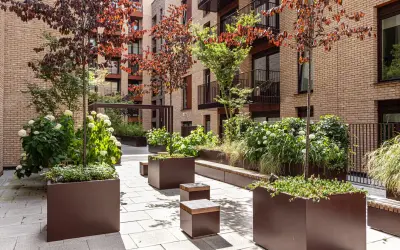
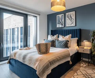
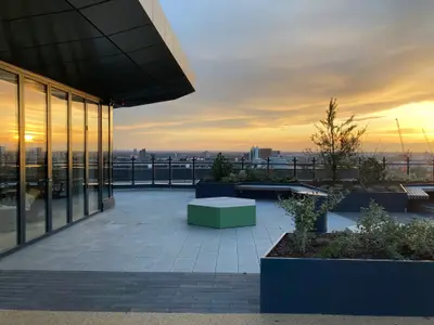
A diverse range of high-specification homes are available to suit various needs, from contemporary studios to spacious one, two, and three-bedroom apartments. Each unit is thoughtfully designed with high ceilings and large windows that flood the interiors with natural light. Kitchens are fully integrated, and residents have the flexibility of choosing between furnished or unfurnished options, allowing you to create a space that is truly your own. Life at The Keel is enhanced by an outstanding array of resident amenities. These include: A private, residents-only gym accessible 24/7 A dedicated 24-hour concierge service and on-site management team Secure, gated fob access, CCTV, and 24-hour security for complete peace of mind Convenient on-site car parking and secure bicycle storage Pet-friendly policies, welcoming your furry companions to the community An exclusive residents' waterside terrace, perfect for relaxation The Keel’s location is second to none. Situated on a private quay in the Queen's Dock, it offers a peaceful retreat while being just a short walk from the heart of Liverpool. The vibrant nightlife and cultural attractions of the Royal Albert Dock are on your doorstep, as is the creative hub of the Baltic Triangle. For retail therapy, the extensive shops and restaurants of Liverpool ONE are a brief stroll away. Excellent transport links, including nearby bus routes and easy access to Liverpool Lime Street station, ensure seamless connectivity across the city and beyond. This development is ideal for professionals, couples, and families seeking a high-quality, hassle-free rental lifestyle in one of Liverpool's most desirable locations.
- Developer
- Allsop
- City
- Merseyside
- Neighbourhood
- Liverpool
- Postcode
- L3 4GE
- Address
- Kings Parade
- Total homes
- 240
- Tenure
- Build to rent
Facilities
- Concierge
- Fitness Centre
- Pet Friendly
- Lift
- Bike Storage
- CCTV Coverage in All Common Areas
- Professionally Managed
- On site Security
- Residents' Lounge
- Co-working Space
- Meeting Rooms
- Resident Events
- Free Wi-Fi
- Underground Parking
Questions about The Keel
›Who is the developer of The Keel?
The Keel is an Allsop development in Liverpool, Merseyside. Allsop has 5 developments listed on Homello.
›What are house prices like in Liverpool?
The median sold price in Liverpool was £210,000 over the last 12 months (6,771 sales, +5.0% on the year before), or £230 per square foot, from HM Land Registry data. The house prices in Liverpool page has the trend, prices by property type and every street.
›What type of homes are at The Keel?
The Keel offers apartments, 240 homes in total. Homes are let by the operator by Allsop.
Location
Kings Parade, L3 4GE
Nearest stations
- Liverpool James Street Station 0.8 milesMerseyrail
- Liverpool Central Loop Line Station 0.8 milesMerseyrail
- Liverpool Central Station 0.8 milesMerseyrail
- Brunswick Station 0.9 milesMerseyrail
Nearest schools
- Liverpool Life Sciences UTC 0.4 milesSecondary · ages 14–19
- The Studio School Liverpool 0.4 milesSecondary · ages 14–19 Good
- St Vincent de Paul Catholic Primary School 0.5 milesPrimary · ages 3–11
- LIPA School 0.7 milesAll-through · ages 4–16
Nearest supermarkets
- Tesco Express Convenience store 0.4 miles
- Spar Convenience store 0.4 miles
- Asda Express Convenience store 0.5 miles
- Tesco Large supermarket 0.7 miles
Eating out nearby
Within half a mile: 36 restaurants and cafes, 15 pubs and bars, 1 takeaway.
- Fika Coffee Shop 0.2 milesRestaurant or cafe
- Centerplate UK 0.2 milesRestaurant or cafe
- McDonald's 0.2 milesRestaurant or cafe
- Kfc 0.2 milesRestaurant or cafe
Straight-line distances; actual routes will be longer. Stations from NaPTAN, with their lines powered by TfL Open Data; schools from the Department for Education register, with the latest Ofsted signal; supermarkets from Geolytix Retail Points; places to eat from the Food Standards Agency's register of food businesses.
Area insights
The Liverpool neighbourhood around this development.
Sources: HM Land Registry price paid data, Police.uk, Historic England, ONS Census 2021, Ofcom Connected Nations, Environment Agency. Planning offices.

We have not been able to confirm current prices here recently.