Sweetfields, phase 1 by PLATFORM_ / Housing Growth Partnership · Sweetfields, Sweet Street West, Holbeck, Leeds, West Yorkshire LS11 9AW
Completing 2027
Built by PLATFORM_ / Housing Growth Partnership. Homes in Leeds sold for a median £245,000 over the last year, £278 per sq ft; see house prices in Leeds.
About Sweetfields, phase 1
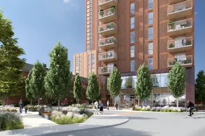
Sweetfields phase one is a development of 451 purpose-built rental apartments on Sweet Street West in Holbeck, south of Leeds city centre. PLATFORM_ and Housing Growth Partnership are delivering the homes with contractor Winvic. The first phase has topped out and is progressing through façade and internal fit-out work, with completion and launch targeted for early 2027.
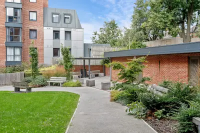
The planned apartment range includes studios and homes with one, two or three bedrooms. Shared facilities are set to include a gym, residents’ lounges, co-working space, private dining and roof terraces, with outdoor fitness and children’s play areas. Electric vehicle charging is also planned. This phase forms part of the larger Sweetfields neighbourhood, whose later residential buildings and commercial spaces have separate delivery programmes.
- Developer
- PLATFORM_ / Housing Growth Partnership
- City
- West Yorkshire
- Neighbourhood
- Leeds
- Postcode
- LS11 9AW
- Address
- Sweetfields, Sweet Street West, Holbeck
- Total homes
- 451
- Tenure
- Build to rent
Facilities
- Gym (Planned)
- Residents’ lounge (Planned)
- Co-working (Planned)
- Private dining (Planned)
- Roof terrace (Planned)
- Play area (Planned)
- EV charging (Planned)
Questions about Sweetfields, phase 1
›Who is the developer of Sweetfields, phase 1?
Sweetfields, phase 1 is a PLATFORM_ / Housing Growth Partnership development in Leeds, West Yorkshire.
›Are homes available to rent at Sweetfields, phase 1?
Sweetfields, phase 1 is marked "coming soon", completing 2027. Use the enquiry button to check current availability with PLATFORM_ / Housing Growth Partnership.
›What are house prices like in Leeds?
The median sold price in Leeds was £245,000 over the last 12 months (7,342 sales, +1.0% on the year before), or £278 per square foot, from HM Land Registry data. The house prices in Leeds page has the trend, prices by property type and every street.
Location
Sweetfields, Sweet Street West, Holbeck, LS11 9AW
Nearest stations
- Leeds Station 0.5 milesCrossCountry, LNER, Northern, TransPennine
- Burley Park Station 2.0 milesNorthern
- Cottingley Station 2.1 milesNorthern, TransPennine
- Headingley Station 2.7 milesNorthern
Nearest schools
- Lane End Primary School 0.3 milesPrimary · ages 3–11
- Cockburn Reach Academy 0.5 milesSpecial · ages 5–11
- Beeston Hill St Luke's Church of England Primary School 0.6 milesPrimary · ages 3–11
- The Ruth Gorse Academy 0.6 milesSecondary · ages 11–16 Outstanding
Nearest supermarkets
- Tesco Express Convenience store 0.2 miles
- Asda Living Superstore 0.4 miles
- The Food Warehouse Supermarket 0.4 miles
- Marks and Spencer Travel SF Convenience store 0.4 miles
Eating out nearby
Within half a mile: 56 restaurants and cafes, 24 pubs and bars, 13 takeaways.
- Proper Food 4U 0.1 milesTakeaway
- For-trea Drapers Yard 0.1 milesRestaurant or cafe
- Grove Inn 0.2 milesPub or bar
- Fratellos 0.2 milesRestaurant or cafe
Straight-line distances; actual routes will be longer. Stations from NaPTAN, with their lines powered by TfL Open Data; schools from the Department for Education register, with the latest Ofsted signal; supermarkets from Geolytix Retail Points; places to eat from the Food Standards Agency's register of food businesses.
Area insights
The Leeds neighbourhood around this development.
Sources: HM Land Registry price paid data, Police.uk, Historic England, ONS Census 2021, Ofcom Connected Nations, Environment Agency. Planning offices.

Register for launch pricing and availability.
Details last confirmed on 21 October 2026.