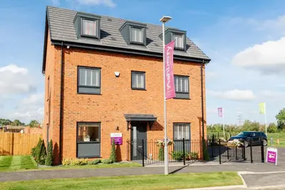
Poppy Fields by Ashberry Homes · The East Of Busk Lane, Church Fenton, West Yorkshire, LS24 9SE
Completed 2025
Ashberry Homes has 48 developments on Homello. Homes in Tadcaster sold for a median £315,000 over the last year, £296 per sq ft; see house prices in Tadcaster.
About Poppy Fields
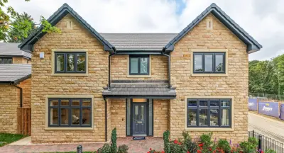
Poppy Fields is a collection of 124 new build homes by Ashberry Homes, a division of Bellway, located on Busk Lane in the village of Church Fenton, West Yorkshire (LS24 9SE). The development occupies part of the site of the former RAF base and comprises a varied selection of property types, ranging from two-bedroom mews houses up to four-bedroom detached homes. The development plan includes a mix of styles to appeal to various demographics, including first-time buyers and growing families.
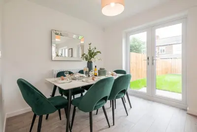
Property types span two-bedroom mews, three-bedroom semi-detached, and four-bedroom detached houses. A known three-bedroom detached house style, 'The Bouvardia,' features an open-plan kitchen, dining, and family area, alongside two double bedrooms, and an en-suite to the principal bedroom. Homes are built with modern specifications, typically incorporating excellent insulation and access to fast internet connectivity. While design and brickwork have received positive feedback from customers at other developments, prospective buyers should note that developer reviews are mixed, with some reporting initial snagging issues and varying levels of site management availability. Poppy Fields benefits from its semi-rural village setting with strong commuter links. Church Fenton train station is located approximately 0.5 miles from the village centre and offers direct rail services to major regional hubs. The fastest direct services connect Church Fenton to York in as little as 11 to 12 minutes, and to Leeds in as little as 18 to 27 minutes, making the location a practical base for commuting professionals. Road access provides straightforward connectivity to the regional network, with the A1(M) and A64 in close proximity. Local amenities in Church Fenton include a post office, a pub, a hair salon, and the volunteer-run Church Fenton Community Shop, which offers fresh produce, household essentials, a café, and click-and-collect services. A wider range of services, including a supermarket, pharmacies, banks, and additional dining options, is available in the nearby town of Tadcaster. The historic city of York, offering extensive cultural and retail amenities, is approximately a 30-minute drive. Ashberry Homes aims to provide a high level of customer care and abides by the New Homes Quality Code. The development consists of 124 units in total, with various phases of build and completion. Availability of specific house types (2, 3, and 4-bedroom designs) and current reservation prices are plot-specific. To check the completion status of individual plots, confirm current pricing, and arrange a viewing of any show homes, interested parties are advised to contact the dedicated sales team directly.
- Developer
- Ashberry Homes
- City
- West Yorkshire
- Neighbourhood
- Church Fenton
- Postcode
- LS24 9SE
- Address
- The East Of Busk Lane, Church Fenton, West Yorkshire, LS24 9SE
- Total homes
- 124
- Completed
- 2025
- Tenure
- For sale
Facilities
- Parking
- Garden
Questions about Poppy Fields
›Who is the developer of Poppy Fields?
Poppy Fields is an Ashberry Homes development in Church Fenton, West Yorkshire. Ashberry Homes has 48 developments listed on Homello.
›Is Poppy Fields still selling?
Poppy Fields: completed 2025. Use the enquiry button to check current availability with Ashberry Homes.
›What are house prices like in Tadcaster?
The median sold price in Tadcaster was £315,000 over the last 12 months (153 sales, +8.6% on the year before), or £296 per square foot, from HM Land Registry data. The house prices in Tadcaster page has the trend, prices by property type and every street.
›What type of homes are at Poppy Fields?
Poppy Fields offers houses, 124 homes in total, completed 2025. Homes are sold outright by Ashberry Homes.
Location
The East Of Busk Lane, Church Fenton, West Yorkshire, LS24 9SE
Nearest stations
- Church Fenton Station 1.1 milesNorthern, TransPennine
- Ulleskelf Station 1.4 milesNorthern, TransPennine
- Sherburn-in-Elmet Station 2.8 milesNorthern
- South Milford Station 4.1 milesNorthern, TransPennine
Nearest schools
- Kirk Fenton Church of England Primary School 0.8 milesPrimary · ages 3–11 Good
- Barkston Ash Catholic Primary School, a Voluntary Academy 2.5 milesPrimary · ages 4–11
- Sherburn Hungate Primary School 3.0 milesPrimary · ages 3–11 Good
- Cawood Church of England Voluntary Aided Primary School 3.1 milesPrimary · ages 3–11 Good
Nearest supermarkets
- The Co-operative Food Supermarket 3.1 miles
- Spar Convenience store 3.2 miles
- Tesco Express Convenience store 3.2 miles
- Aldi Supermarket 3.3 miles
Eating out nearby
Within half a mile: 1 restaurant or cafe.
- The Leeds East Airport Bistros 0.1 milesRestaurant or cafe
- The Fenton Flyer 0.7 milesPub or bar
- Sunar Bangla 1.0 milesRestaurant or cafe
- The Rythre Arms 1.9 milesRestaurant or cafe
Straight-line distances; actual routes will be longer. Stations from NaPTAN, with their lines powered by TfL Open Data; schools from the Department for Education register, with the latest Ofsted signal; supermarkets from Geolytix Retail Points; places to eat from the Food Standards Agency's register of food businesses.
Area insights
The Selby neighbourhood around this development.
Sources: HM Land Registry price paid data, Police.uk, Historic England, ONS Census 2021, Ofcom Connected Nations, Environment Agency. Planning offices.

We have not been able to confirm current prices here recently.