Granary Quay by Colby River · 365 Glasgow Harbour Terraces G11 6FB
Completed
Colby River has 5 developments on Homello.
About Granary Quay
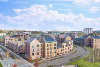
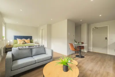
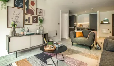
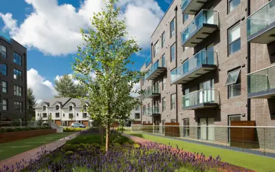
Granary Quay is Colby River’s rental development on the north bank of the River Clyde in Glasgow’s West End. It offers studios and one- and two-bedroom apartments, with furnished and selected unfurnished options. Private outdoor space varies between full-length and Juliet balconies and terraces.
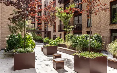
Partick station and the surrounding West End neighbourhood provide local transport, shopping and leisure options. Residents have a 24-hour gym, co-working space, lounges and a shared house kitchen. A club room can be booked for meetings or private gatherings, and a waterfront courtyard provides outdoor space. Bike storage, parking and broadband are also advertised, with pets welcome. The operator should confirm the selected apartment’s furnishing, outdoor space, parking terms and current booking arrangements before a tenancy is agreed.
- Developer
- Colby River
- City
- Glasgow
- Neighbourhood
- Glasgow
- Postcode
- G11 6FB
- Address
- 365 Glasgow Harbour Terraces
- Tenure
- Build to rent
Facilities
- Gym (24 hours)
- Co-working
- Residents’ lounge
- Residents’ kitchen
- Meeting room (Bookable club room)
- Garden
- Bike storage
- Parking
- Broadband
- Pet friendly
Questions about Granary Quay
›Who is the developer of Granary Quay?
Granary Quay is a Colby River development in Glasgow. Colby River has 5 developments listed on Homello.
›Are homes available to rent at Granary Quay?
Granary Quay is marked "now selling", completed. Use the enquiry button to check current availability with Colby River.
Location
365 Glasgow Harbour Terraces, G11 6FB
Nearest stations
- Partick Station 0.5 milesScotRail · Glasgow Subway
- Govan Station 0.7 milesGlasgow Subway
- Hyndland Station 0.8 milesScotRail
- Kelvinhall Station 0.9 milesGlasgow Subway
Nearest schools
- Bowness-on-Solway Primary School 76.9 milesPrimary · ages 3–11
- Silloth Primary School 78.2 milesPrimary · ages 3–11 Outstanding
- Solway Community School 78.3 milesSecondary · ages 11–16
- Kirkbride Primary School 80.6 milesPrimary · ages 3–11
Nearest supermarkets
- Marks and Spencer Simply Food Supermarket 0.4 miles
- Sainsburys Supermarket 0.5 miles
- The Co-operative Food Convenience store 0.5 miles
- Morrisons Large supermarket 0.6 miles
Eating out nearby
Within half a mile: 27 restaurants and cafes, 8 pubs and bars, 22 takeaways.
- Burger King 0.1 milesTakeaway
- Ceqwa Takeaway 0.1 milesTakeaway
- Thornwood Chippy 0.1 milesTakeaway
- The Thornwood Bar 0.1 milesPub or bar
Straight-line distances; actual routes will be longer. Stations from NaPTAN, with their lines powered by TfL Open Data; schools from the Department for Education register, with the latest Ofsted signal; supermarkets from Geolytix Retail Points; places to eat from the Food Standards Agency's register of food businesses.
Area insights
The neighbourhood around this development.
Sources: HM Land Registry price paid data, Police.uk, Historic England, ONS Census 2021, Ofcom Connected Nations, Environment Agency. Planning offices.
Register for launch pricing and availability.
Details last confirmed on 21 October 2026.