Skip to content
New homes
1/9
POA
Price on application

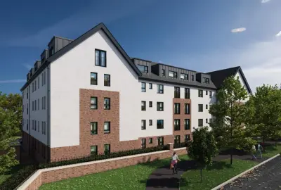
Cottonyards by Westpoint Homes · Commercial Road, Glasgow, Glasgow City G5 0EU

1–2 beds
For sale

Westpoint Homes has 2 developments on Homello.

About Cottonyards

Cottonyards is a new build development by Westpoint Homes in Glasgow, Glasgow City (G5 0EU). The homes are on and around Commercial Road. This page was made on 10 October 2026 from estate agents' listings for the development.

Developer
Westpoint Homes
City
Glasgow City
Neighbourhood
Glasgow
Postcode
G5 0EU
Address
Commercial Road, Glasgow, Glasgow City
Bedrooms
1–2
Tenure
For sale

On the market at Cottonyards

Estate agents list one home for sale at Cottonyards. Agent listings do not say whether a home is new or a resale, so this may be either.

  • For sale from £220,000

Questions about Cottonyards

›Who is the developer of Cottonyards?

Cottonyards is a Westpoint Homes development in Glasgow, Glasgow City. Westpoint Homes has 2 developments listed on Homello.

Location

Commercial Road, Glasgow, Glasgow City, G5 0EU

Nearest stations

  • Bridge Street Station 0.5 miles
    Glasgow Subway
  • Argyle Street Station 0.6 miles
    ScotRail
  • St Enoch Station 0.7 miles
    Glasgow Subway
  • West Street Station 0.7 miles
    Glasgow Subway

Nearest schools

  • Bowness-on-Solway Primary School 74.1 miles
    Primary · ages 3–11
  • Silloth Primary School 75.6 miles
    Primary · ages 3–11 Outstanding
  • Solway Community School 75.6 miles
    Secondary · ages 11–16
  • Kirkbride Primary School 77.8 miles
    Primary · ages 3–11

Nearest supermarkets

  • The Co-operative Food Supermarket 0.2 miles
  • Aldi Supermarket 0.5 miles
  • The Food Warehouse Supermarket 0.5 miles
  • Spar Convenience store 0.6 miles

Eating out nearby

Within half a mile: 26 restaurants and cafes, 8 pubs and bars, 7 takeaways.

  • Gorbals Parish Church 0.1 miles
    Restaurant or cafe
  • G5 Fruit, Wholefoods and Deli 0.2 miles
    Restaurant or cafe
  • Gorbals Youth Café 0.2 miles
    Restaurant or cafe
  • Ann's Fry Fish And Chip Shop 0.2 miles
    Takeaway

Straight-line distances; actual routes will be longer. Stations from NaPTAN, with their lines powered by TfL Open Data; schools from the Department for Education register, with the latest Ofsted signal; supermarkets from Geolytix Retail Points; places to eat from the Food Standards Agency's register of food businesses.

Area insights

The neighbourhood around this development.

Sources: HM Land Registry price paid data, Police.uk, Historic England, ONS Census 2021, Ofcom Connected Nations, Environment Agency. Planning offices.

Developed by
Westpoint Homes
2 developments · 2 areas tracked
More developments from this developer

Register for launch pricing and availability.
Similar developments nearby

More by Westpoint Homes

View all 2 →