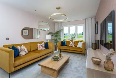
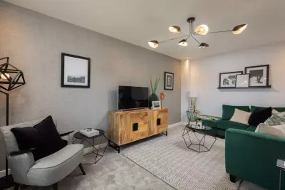
Amber Rise by Ashberry Homes · Whiteley Road, Ripley, Derbyshire DE5 3QL
Ashberry Homes has 48 developments on Homello. Homes in Ripley sold for a median £207,250 over the last year, £237 per sq ft; see house prices in Ripley.
About Amber Rise
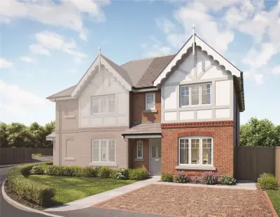
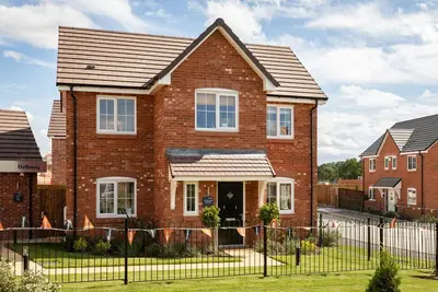
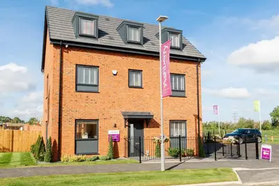
Amber Rise is a new build homes development by Ashberry Homes, a trading division of Bellway Homes Limited, located off Whiteley Road in the market town of Ripley, Derbyshire (Postcode DE5 3QL). The development is situated within the Amber Valley, offering a mix of new residential properties designed for various buyer profiles, from first-time buyers to growing families. The current phase of new build homes at Amber Rise features a selection of 2, 3, and 4-bedroom houses.
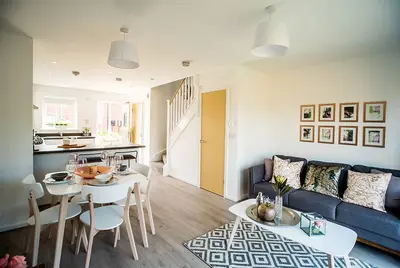
Specific house types include the three-bedroom semi-detached ‘The Valerian’ and the four-bedroom ‘Albertine’. Prospective buyers should contact the dedicated sales team for the most current pricing and plot availability, as these figures are subject to change and stock availability. Ashberry Homes state that the properties at Amber Rise are built with energy efficiency in mind, incorporating modern construction practices intended to achieve lower running costs and a greener standard of living. Homes feature modern specifications and designs, with the option for personalisation through the developer's 'Personal Touch' scheme. For example, the three-bedroom 'The Valerian' house type offers an open-plan living and dining area with maximum dimensions of 5.726m x 4.668m (18’9” x 15’4”). The development layout includes dedicated on-site open space for resident use. The developer also offers various purchasing initiatives, including Assisted Move, Home Exchange, and the Own New Rate Reducer scheme. Ashberry Homes also highlights their general track record, noting that some site managers have received 'Pride in the Job awards', though prospective purchasers are advised to research the developer's customer satisfaction on a development-specific basis prior to commitment. Amber Rise is strategically located to benefit from both local convenience and major road network access. The area is easily accessible from both the M1 motorway and the A38 trunk road. This provides straightforward routes for commuters, with Derby and Nottingham being a short drive away. Public transport options in Ripley include local bus routes such as the 147, which connects to Ambergate, and routes 6.2 and 6.3 serving Belper. The nearest railway station providing connections to mainline services would be either Alfreton or Belper. A drive of approximately 10 minutes provides access to the Shipley nature reserve, while the Peak District is also within a short driving distance. Ripley is a traditional market town, hosting a regular charter market on Fridays and Saturdays. The town centre maintains a strong independent retail scene alongside high street options, featuring specific local businesses like Walkers Butcher Shop, Monty's Cafe Bar, and Hursts Chemist. The nearby Denby Pottery shopping village is also a noted local attraction. Families moving to the development will find several well-regarded primary education options within a five-minute drive, including Ripley Infant and Junior Schools, Waingroves Primary School, and Codner Community Primary. For recreation, Crossley Park offers a Green Flag-awarded space with a paddling pool and bandstand. The development is nearing completion on some phases, with final homes remaining. Availability is fluid, and prospective buyers are strongly encouraged to contact the Ashberry Homes sales office at Amber Rise on Whiteley Road to confirm current property-specific prices, house type availability (2, 3, or 4 bedrooms), and to arrange a viewing appointment. Interested parties can enquire about plot-specific details and warranty information directly with the developer.
- Developer
- Ashberry Homes
- City
- Derbyshire
- Neighbourhood
- Ripley
- Postcode
- DE5 3QL
- Address
- Whiteley Road, Ripley, Derbyshire
- Tenure
- For sale
Questions about Amber Rise
›Who is the developer of Amber Rise?
Amber Rise is an Ashberry Homes development in Ripley, Derbyshire. Ashberry Homes has 48 developments listed on Homello.
›What are house prices like in Ripley?
The median sold price in Ripley was £207,250 over the last 12 months (344 sales, −9.1% on the year before), or £237 per square foot, from HM Land Registry data. The house prices in Ripley page has the trend, prices by property type and every street.
Location
Whiteley Road, Ripley, Derbyshire, DE5 3QL
Nearest stations
- Langley Mill Station 3.2 milesEast Midlands, Northern
- Ambergate Station 3.7 milesEast Midlands
- Belper Station 3.7 milesEast Midlands
- Alfreton Station 4.3 milesEast Midlands, Northern
Nearest schools
- The Ripley Academy 0.4 milesSecondary · ages 11–18
- Waingroves Primary School 0.5 milesPrimary · ages 4–11 Good
- Ripley Junior School 0.6 milesPrimary · ages 7–11 Good
- Ripley Infant School 0.6 milesPrimary · ages 4–7 Good
Nearest supermarkets
- The Co-operative Food Large supermarket 0.7 miles
- The Co-operative Food Convenience store 0.8 miles
- Lidl Supermarket 0.9 miles
- Tesco Express Convenience store 0.9 miles
Eating out nearby
Within half a mile: 2 restaurants and cafes, 2 pubs and bars.
- Butterley Cafe <0.1 milesRestaurant or cafe
- The Groovers Arms 0.2 milesPub or bar
- Springs Of Living Water - Warm Space 0.3 milesRestaurant or cafe
- Holly Bush 0.4 milesPub or bar
Straight-line distances; actual routes will be longer. Stations from NaPTAN, with their lines powered by TfL Open Data; schools from the Department for Education register, with the latest Ofsted signal; supermarkets from Geolytix Retail Points; places to eat from the Food Standards Agency's register of food businesses.
Area insights
The Amber Valley neighbourhood around this development.
Sources: HM Land Registry price paid data, Police.uk, Historic England, ONS Census 2021, Ofcom Connected Nations, Environment Agency. Planning offices.

We have not been able to confirm current prices here recently.